My first blog entry, this is big.... AND it’s published for y'all to read, Yikes! Where to start?? So I mentioned a little bit in the section about me how much I love to hike, run, bike, and just explore in general. Ok wait, Lets back track a little- we all have Facebook, I mean who doesn't these days and if you are anything like me you love to share your adventures. This island has so many beautiful hidden gems, so much history & amazing landscape and not to mention SO MANY GOOD HIKING TRAILS. Through the years I have gotten a lot of comments from family, friends and complete strangers about how they love my adventures and can't wait to see where I go next so I took the plunge and decided to write about them in hopes that I can share with everyone just what this little island offer. Here goes nothin'......
I guess you could call this past weekend the first of many busy weekends that are yet to come. Early Saturday morning I loaded up the car with whatever running and hiking gear I thought I would need for the day and headed west on the TCH to Clarenville. For those of you who don't know me, I am a hiking fanatic and I'm also a little obsessed with running. This past weekend was my first race out of town so I was a little anxious to see what I was getting myself into. I was really surprised to see how well the event was organized and even more surprised with how nice the weather was in Clarenville.
It didn't seem logical to drive all the way to Clarenville just to run a 5k race, which is about 1.5 hours from my hometown, so I thought I would make a day of it and hike to the site of the Burgoyne's Cove Plane Crash located in Burgoyne's Cove just outside of Clarenville, also known as Dead Man’s Bay. Luckily for me I got to share this lovely adventure with three great friends of mine, one of who is also my running partner.
When the race was over and we had stuffed our faces with a McDonalds pancake breakfast, we gathered our things and headed towards Burgoyne's Cove. Upon arriving to the entrance to the trail we weren't sure if we immediately regretted our decision of deciding to do this hike or not. From bottom to top it is approximately a 30 minute climb to the site of the crash. After running a 5km race we weren't sure what we were thinking, but what I can say is BOY was it worth it. The hike up to the top of the hill was absolutely lovely. The forest was full of lush green moss and there was a lovely stream running alongside the trail, not to mention the several benches that were readily available if one felt so inclined to take a breather.
So let me tell you a little bit about the crash.
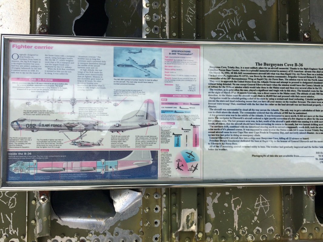
On March 18th, 1953, an RB-36 Bomber plane also known as the Peacemaker which is the largest of its kind having 10 engines-six piston & four jet was on the way to Maine, US when inclement weather struck causing the bomber to crash into the hillside just 800 feet above sea level in Burgoyne's Cove, Trinity Bay, Newfoundland. This particular plane was developed during the Second World War by the US Air Force- a long range, strategic nuclear bomber. It was designed to carry 33,000 KG of weight, travel 10,000 Kms without touching down for fuel or 50 hours air time. Pictured below is some information that is made available to hikers once reaching the crash site.
When the race was over and we had stuffed our faces with a McDonalds pancake breakfast, we gathered our things and headed towards Burgoyne's Cove. Upon arriving to the entrance to the trail we weren't sure if we immediately regretted our decision of deciding to do this hike or not. From bottom to top it is approximately a 30 minute climb to the site of the crash. After running a 5km race we weren't sure what we were thinking, but what I can say is BOY was it worth it. The hike up to the top of the hill was absolutely lovely. The forest was full of lush green moss and there was a lovely stream running alongside the trail, not to mention the several benches that were readily available if one felt so inclined to take a breather.
So let me tell you a little bit about the crash.
On March 18th, 1953, an RB-36 Bomber plane also known as the Peacemaker which is the largest of its kind having 10 engines-six piston & four jet was on the way to Maine, US when inclement weather struck causing the bomber to crash into the hillside just 800 feet above sea level in Burgoyne's Cove, Trinity Bay, Newfoundland. This particular plane was developed during the Second World War by the US Air Force- a long range, strategic nuclear bomber. It was designed to carry 33,000 KG of weight, travel 10,000 Kms without touching down for fuel or 50 hours air time. Pictured below is some information that is made available to hikers once reaching the crash site.
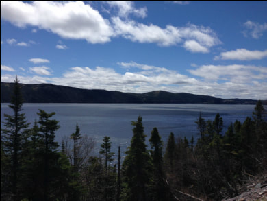
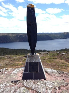
All 23 men that were on board were killed that foggy night in March. There is a memorial on the very top of the hill dedicated to all the men who lost their lives on that fateful night. From here you can see the remains of the plane in the bushes and the woods, you also get a panoramic view of Clarenville, White Hills and surrounding areas. On a beautiful sunny day or what I like to call a bluebird day there is nothing more serene than the view around you.
 If you are interested in hiking to the crash site, here are the directions: Turn off the highway in Clarenville at Manitoba Drive, than take a left turn on to Shoal Harbour Drive, continue east along Route 230-A towards Bonavista through Shoal Harbour and Milton. Then take Route 232 from George's Brook, through Barton, Harcourt, Gin Cove, Monroe, Clifton, and finally at the end of the road, Burgoyne's Cove. | 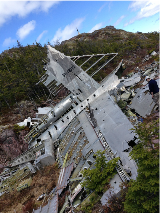 |
When you enter Burgoyne's Cove, continue on the main road until you see a sign on your left for Newfoundland Slate Company. Make the left turn and approximately 1-2 minutes after the road turns to dirt, you take a right (there will be another Newfoundland Slate Company Sign Here), drive 4.5 km (passing the slate plant) until you see a small sign on the left indicating the crash site. The road is a little washed out the closer you get to the trail head but it is manageable in a small car.

For more information on this particular crash, please visit the link below.
http://www.thetelegram.com/Motoring/2008-11-05/article-1454933/Hike-into-History/
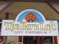
One cannot simply leave Clarenville and not go to The Barn Loft. They have the BEST selection of fancy carbonated drinks, yummy fudge and who doesn't love Ice cream and candy. It is the perfect place to go for a post hike treat- not to mention they also have a variety of house and gift ware.
They are located at 28 Harbour Drive.
See you again soon!
-E
http://www.thetelegram.com/Motoring/2008-11-05/article-1454933/Hike-into-History/
One cannot simply leave Clarenville and not go to The Barn Loft. They have the BEST selection of fancy carbonated drinks, yummy fudge and who doesn't love Ice cream and candy. It is the perfect place to go for a post hike treat- not to mention they also have a variety of house and gift ware.
They are located at 28 Harbour Drive.
See you again soon!
-E
EDIT: Because we updated our site we had to delete old posts and unfortunately comments went with them. There were some comments on this post that I chose not to part with so they have been pasted below.
Donna Summers( [email protected] )
5/24/2015 09:34:41 am
Very well written and the pictures are awesome. Beauty job daughter, I'd like to do that hike. XOXO!
William P Maher Jr( [email protected] )
6/1/2015 02:41:34 am
Nice photos and yet, it is a beautiful area. From the photo of the propeller 'monument' I cannot see if the plate with the names of the fliers is still attached. Is it?
My father was on that flight; my wife and I visited the site several years ago. The hospitality and friendship from the Canadians who lived in the area was wonderful. (We stayed at a B&B in Britannia, on Random Island across the Sound).
Best regards
Erica( [email protected] )
6/29/2015 05:22:15 pm
Hi William,
So sorry for the delay in my response.
The Plate with all of the names is still attached- the monument is a fantastic tribute to all those involved and of course to your father!
I hope you enjoyed your stay here in Newfoundland. If you are ever in Newfoundland again, don't hesitate to touch base with me.
Thank you so much for reading my post. I can't tell you how much I enjoyed this hike & the history behind it.
All the best
Erica
 RSS Feed
